
Atascadero Creek- 2,600 Acre Feet Capture and Storage Project
Storing Water in the Riparian Corridor

Patterson overcross, Atascadero creek
Points of interest....
*Capture flood runoff waters at creek locations
*Store water temporarily in small local reservoirs
*Pump stored water up bike-path and creek corridor right of way
*Irrigate local parks, farms, golf courses, schools
*Irrigate using proprietary 2" PVC pipe system with 1/2" holes at 3' centers installed across upper park grounds
* No Title 22- Separate water distribution system
Cube video test below...!
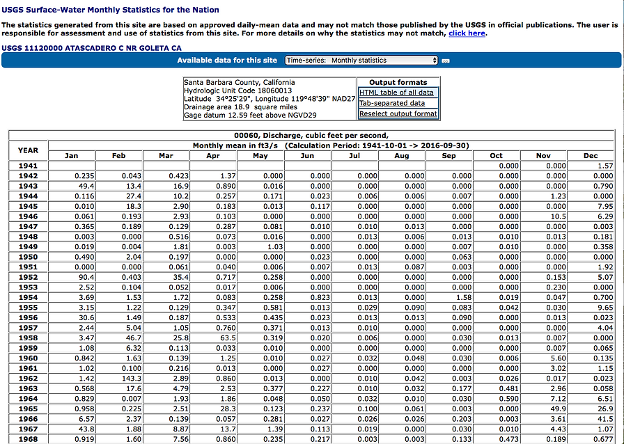
Atascadero creek here at the lower Patterson blvd. crossing produces over 6,000 acre feet a year, on average for the last seventy five years, according to USGS. That's over 1.6 billion gallons lost to the ocean every year.
Our plan is to capture a portion of this storm runoff at the Patterson over cross, a half mile before it dumps into the Pacific. Store this water in a newly built 15 AF reservoir next to the creek and pump this water up the stream corridors to irrigate county parks. Parks like Patterson Open Space, Tuckers Grove, Tabano Open Space, San Marcos High, Goleta Beach Park and even sell to Hidden Oaks Golf and others. By replacing imported water with local water County can save money. 1,000 AF at 1/3 cent per gallon or $1,000 per AF, would save the County $1,000,000 a year. (If calculations are correct*)
County needs to apply for the following permits;
1) Surface Water Diversion Permit- State.
2) 404 permit - Army corps
3) 401 certification from CCRWQCB is required for the Clean Water Act 404 ACOE permit for construction related activities within the aquatic habitat of the creek- 401 certification program manager, Phil Hammer at (805) 549-3882.
4) Enrollment under the Statewide Construction (stormwater) General Permit, Order No. 2009-0009 DWQ (this requires the development of a stormwater pollution prevention plan, or SWPPP). Below is a link to the general permit page; enrollment under this order likely will be required depending on the size of the project.
http://www.waterboards.ca.gov/water_issues/programs/stormwater/construction.shtml
5) Permit from CA Department of Fish and Wildlife if we are doing any significant grading and/or disturbing sensitive habitat, (not) particularly within a creek, and consult directly (biological surveys will likely be required); ACOE typically coordinates with NOAA National Marine Fisheries as part f their 404 process.
6) CEQA EIR process will need to be completed before the project can be permitted and implemented.
7) Modify, and permit as necessary, the existing potable supply distribution system that is currently used to irrigate the parks to isolate it from the proposed (non-potable) irrigation water supply. This will require coordination with the local water purveyor(s), county level drinking water program and perhaps even the SWRCB Division of Drinking Water. ( Note- Not planning spray irrigation, instead use single pipe dribble system)
State Water Resources Control Board has indicated captured stream water can legally by placed on County Parks...
County groundwater recharge will fit into the States new SRP requirements. By deluging creek adjacent County Parks and other grounds with reclaimed creek water, we are essentially storing water in the ground. Water will more slowly percolate out into streams; improving riparian habitats; wildlife; plants; fish coverage; re charging groundwater; increasing county well production and creating river flows for many months past rain events. Thus we store water in the ground and can avoid building huge, costly reservoirs, hopefully.
Credit and thanks to Matt McCarthy 916-341-5310
Matthew.McCarthy@waterboards.ca.gov
Cost for this project are estimated to be under a million, with Lash Construction being the lead contractor due to their locality and experience in building small, local reservoirs. Savings for the County are dependent on how much water can be pumped into county parks and other locations to replace purchased water. The water is not potable but will grow plants, fill aquifers and keep the creeks running in a more natural manner conducive to fish and other wildlife.
Anticipate the biggest hurtle will be Fish and Wildlife/ Diversion permits. So a presenting strategy may be multi-prong to counter objections.
1) We are putting all diverted water back into the water shed and thus are improving river habitat and is part of Counties SRP.
2) Only parks adjacent to creeks are to be irrigated. And the irrigation is not spraying, not sprinklers, not anything to do with public water supply. We will install one pipe across the upper reaches of each park, and the pipe will have simple 1/2 holes at 2' intervals. Thus captured creek water is spread onto the park grass areas en mass, throughly soaking the grounds and storing many thousands of gallons per acre. Any 'excess' water simply runs back into the creek.
3) We only divert when stream flow is above a certain level. We can instal collection cubes (please see video) at predetermined locations in the Patterson over cross area to only collect above a certain flow rate.
4) We are capturing wasted urban runoff water that would naturally be soaking into the aquifer but for urban development is now being dumped straight into creeks from immpermiable roads, parking lots, rooftops... causing overburdening, erosion and harming fish habitat. We are placing this water back into the corridor.
The Plan
permits
costs
Strategy
HERE IS THE SUMP STATION DESIGN FED BY 12" PIPE. SUMP IS LOCATED 300' DOWNSTREAM FROM CUBES COLLECTION SPOT AT PATTERSON. CAPTURED WATER FALLS INTO SUMP, SILTS OUT SOME AND GETS PUPMPED BACK UPSTREAM 400' TO RESERVOIR - SILT AND GRAVEL IS DUMPED OUT OF BOTTOM VIA 12" EXIT PIPE WITH TIME CONTROLLED VALVE OPENING FOR TEN SECONDS EVERY HOUR OF WATER GATHERING FOR EXAMPLE. OR WHEN SILT REACHES CERTAIN LEVEL.


Atascadero creek looking west from Patterson bridge - High water mark 8'H x 45'W
Urban Creek Renewal - Saving Water
Urban growth has created vast tracks of impermeable surfaces roads, rooftops, driveways, freeways and these create massive overburden of local creeks. This over burden destroys and endangers steelhead habitats by flooding after rains and quickly drying up. The flooding causes erosion of banks, depositing soils and mud in creek beds. These extremes can be remediated by the capturing, storage and delayed release of stormwaters. The project sites are at the lower end of Atascadero creek and the middle range of Maria Yngacio at the 101 overdress and is surrounded by tract homes, light industry, farms, rural development, parks, freeway 101 and a single RR track. North from the site a mile away Goleta exists with small light businesses and a hospital , freeways, and tract developments.

Patterson overpass running N/S,
Maria ygnacio east to ocean, left
Video of plan...
At this underpass, Maria Ignacio and Atascadero creek join. We plan to install (4) collection cubes (videos below) at the edge of the riprap (concrete and stones) under the bridge to capture 80+ gallons a second, which adds up to 21.2 acre feet per day possible. There are nearly 110 days realisticaly available for capture in an average year so that makes 2,333 AF per year saved from stormwater runoff.
This water is less than 500 meters from the slew and ocean, and we can now capture, store and send it up stream in 6,800' of pipes to irrigate the many parks along Maria Yngacio, San Jose and Atascadero creeks. These many acre feet will percolate back into the creeks months after rains have stopped. We are storing water in the riparian corridor.
Thus we can increase the time of stream flow into summer, recharge groundwater, keep county wells operating, cut imported water use, spur foliage growth and increase wildlife along the creeks corridors for many miles above the reservoir system.
The collection cubes are shown below, anchored into the riprap area under Patterson overcross. The cubes have open or closed valves inside which are controlled via cables from above on the roadway. Collection can be turned on or off, even remotely. Water is shunted out of each cube, into a 12" pipe that carries water out of the channel 300' away downstream and into a collection sump.
It works like this; As the stream drops in elevation, the 12" exit water pipe runs horizontal along the creek banks and eventually over 300' the water pipe raises above the creek bank and into a sump station on the upper bank.
Thus we can obtain water in a controlled manner, without electricity and the danger and problems of high voltage electric, wires and motors in a raging 9,000 cfs creek...
From there the water is pumped upstream, on the high banks of the creek to a storage reservoir near the junction of the two creeks.

The captured water flows into the sump station, where it is pumped back upstream 500' to a 15.9 acre foot storage reservoir shown below. The reservoir itself takes up about one acre and is 10' below grade, five feet above grade and the berm is made of compacted material dug out to make the depression. The proposed reservoir is located along the bike paths between Atascadero and Maria Ignacio creeks. This view is looking north...
From here the water can be further de-silted in a second stage holding tank in the reservoir. Then it is sent upstream to various parks along the both creeks, tributaries, and to another five acre foot proposed reservoir at San Jose creek adjacent Hwy 101 a mile to the north.


Bike path right of way for irrigation pipes to
Small parks along San Antonio creek, tributary of Maria Yngacio, tributary of Atascadero creek.
Below shows an overview of Atascadero creek capture project; sump area, piping, reservoir and upstream pipe systems.

Cube placemnet
Four cubes will capture water faster and fast is what we need. The rain peaks Atascadero creek typically last 30-50 hours and so 4 cubes will gather 120 gps which boils down to a whooping 31.8 acre feet per day.

Below is how it all works at Atascadero creek... This is the most inexpensive and easiest to construct fish ladder yet devised. Probably $40k instead of $250K for an engineered concrete structure.

cube video test Cold springs creek
Here is a test of our 1/4 scale stormwater collection cube. With the cube in this small flow on Cold Springs creek we calculated five gallons per second output with a stream flow of three knots. Even this small 1/4 scale device is producing 1.325 acre feet per day. It works in low cfs and works better in higher cfs.
The full size version has higher efficiency and several upgrades. Its dimensions are 16" x16" x 6' and 680 lbs of steel, with two valves; An outlet valve which closes off the outlet pipe when not in use, so it doesn't collect mud and gravel if not needed, and a close cube valve that closes the cube off and shunts water into the exit pipe for collection. The full size version has a 256 sq inch input, and 339.29 sq in elliptical outlet into a 12" pipe and will produce 30 gallons per second, or 7 AF a day in a 5 knot stream flow.
We propose four collection cubes on Atascadero for rapid capture in the peak flows, which for this last Jan 23 2017 was over 9,000 cfs or 58,000 gallons per second.
Four cubes will also make the most of the days and weeks after peak flows, typically in the 20 - 40 cfs range.
Watershed Stats
Atascadero creek is 6.28 miles long and drains 18.9 square miles, 12,096 sq acres. Maria Ignacio creek is 7 miles long and drains 6.4 square miles, 4,096 acres. A total of 16,192 acres of drainage area combined.
Atascadero creek shown here drains thousands of acres of tract homes, roads, highways and so... really produces instant urban "floods" from just a half inch of rain. Nearly all this water is wasted and runs off in 10-20 hours. We plan to capture some 30% of it.

Non Permiable runoff creates dry creeks soon after floods
Goleta Middle Basin Is Permeable
Shown below, this stretch of San Antonio creek is dry only two months after our 9" January 23 rain attack. This location is adjacent the county well station. If the central Goleta basin was impermeable, this creek would not be dry two months after a huge rain season. Water is filtering through the ground and into the aquifer. At the lowest reaches of Atascadero Creek water is standing three months after rains and this shows the impermeability of this area. Right up against the Hope Ranch Fault there is a barrier that keeps water from leaching downward. This barrier does not exist in the middle and upper basins. Thus we can recharge aquifers all across these middle and upper basin areas.
A tributary of Atascadero creek, San Antonio creek is impacted by urban rains which are concentrated by streets, rooftops and drain rapidly into creeks causing overburdening and erosion.
This quickly dumped rain water doesn't have a chance to soak into the ground and thus the aquifer cannot not retain rain as it normally would.
Capturing this runoff from each point source would require hundreds of large (12"+) pipes up and down the creek and many collection and pumping points. If 40-50 years ago designers had installed individual capture and swail systems things would be different. Now using the cube design we can easily control and regulate the capture rates at will.
By capturing and re cycling this urban street runoff water back into parks and fields, it can infiltrate into the aquifer and recharge groundwater basins, which will keep streams flowing many months after normal rains, recharge aquifers, grow more plant life, making for better fish habitat and keeping riparian corridor plant life producing more and better water.

Bridge over Atascadero creek
This bridge over Atascadero creek is adjacent the Municipal Golf course we can send water to. They will get lower priced water, the county will not have to import chlorinated water from northern cal and Atascadero creek will get additional water percolation back from the greens.
Atascadero Creek 100 meters upstream of patterson blvd


Maria Ignacio and bike path crossing 100 meters above hollister April 4 2017
